Zenseact safety software to use Google’s new HD map
Safety software from Zenseact will use Google’s new HD map data to deliver a safer and more enjoyable assisted driving experience in the Volvo EX90 and Polestar 3.
4 min read
Gothenburg 9 January 2023. Safety software from Zenseact will use Google’s new HD map data to deliver a safer and more enjoyable assisted driving experience in the Volvo EX90 and Polestar 3. Highly detailed and up-to-date road information from Google’s HD map will complement sensor information in Zenseact’s OnePilot software, which constitutes the core technology of Volvo Cars’ Pilot Assist. With OnePilot on board, Volvo EX90 and Polestar 3 will be the first vehicles to deploy Google’s HD map.
Today, cars use standard-definition maps designed for navigation/routing purposes. High-definition maps are a relatively new type of map used in assisted and autonomous driving that contain details not usually present on traditional maps for human drivers but critical for assisted driving computation. For example, Google’s HD map delivers precise lane-level detail like lane markers and localization objects like signs that help the vehicle orient itself on the road and plan its path forward.
”We’re very excited for our software to use Google’s new HD map in the latest vehicles from Volvo Cars. The HD map will enable us to develop our next-generation safety software for assisted driving and assist us in our journey to eyes-off autonomous driving,” Ödgärd Andersson, CEO at Zenseact, explains.
To effectively power assisted and future autonomous driving technologies, Google’s HD map is paired closely with the perception and localization systems found onboard the Volvo EX90 and Polestar 3. This will ensure faster and more reliable updates of map data and allow OnePilot to operate with the best information at hand.
“The car’s sensors and our software will compare the immediate surroundings with the map’s view of the world. When vehicles use the HD map, if the roadway objects detected by the vehicle sensors differ from the information Google has, that signal may help improve the HD map for everyone. In addition, we can add feature-specific layers with information relevant to our OnePilot functionality. This will enable the fleet to learn and handle the driving task better collectively over time,” Per Lofter, Product Owner Map Platform at Zenseact, says.
How high-definition maps help us power the next generation of assisted and autonomous driving systems
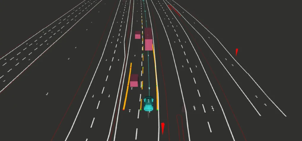
High-definition maps, in general, play an important role in Zenseact’s safety technology., The company’s flagship product OnePilot, software for advanced driver assistance aiming towards autonomous driving, helps the driver avoid collisions, offering to take over parts of the driving tasks. To do so safely and reliably, the car needs a clear view of the vehicle’s surroundings. OnePilot, with input from hardware such as cameras, radar, and lidar, detects road shapes, traffic signs, lane markers, other road users, etc., and fuses real-time data with information from high-definition maps to provide a reliable view of the world.
High-definition maps provide information about the road beyond the range of the sensors, e.g., behind crests, around corners, or behind obstructing objects. In cases of limited visibility (for instance, a truck blocking the sensor’s field of vision), this critical information might only be obtained from a map. While cameras observe the immediate surroundings of the car and the lidar extends the range, especially in darkness, high-definition maps have the potential to provide an unobstructed, birds-eye view of the world, enabling more stable operation and planning.
Real-time use of high-definition maps has thus been a crucial element of OnePilot. Our safety software can help a car adjust the driving to what’s beyond the next turn, keep a vehicle centered in the lane even when road markings are hard to spot and help drivers determine whether a specific road is approved for unsupervised driving. The detailed information in high-definition maps makes it possible for our software to position a vehicle in the correct lane down to the decimeter, enabling safer and smoother planning of lane changes while taking into consideration the route as well as other vehicles. By doing so, Zenseact is fighting to make roads safe for everyone.